
Synopsis:
In enterprise agriculture, the choice between satellite monitoring and ground-level sensors is often framed as an “either-or” debate. However, as operations scale across thousands of hectares, the limitations of both become apparent. Satellite data provides the “where” but often lacks the “why,” while ground intelligence provides the “what/why” but fails to scale geographically. This blog explores how intelligence gaps emerge and why the future of profitable farming lies in an integrated model where AI orchestrates both sources into a single source of truth.
The Intelligence Dilemma in Large-Scale Agriculture
At a small scale, a farmer’s intuition and daily walk-throughs provide enough intelligence to manage a field. (However, in today’s climate-impacted world, intuition and even knowledge passed over generations could fail!) In the case of an enterprise managing a global supply chain or thousands of contracted acres, that intuition vanishes.
The dilemma is simple: you need to see data across the broader region, while at the same time understanding exactly what is happening on each farm. Scaling up need not mean choosing between “broad or wide dataset” (satellites) or “narrow or in-depth” dataset (sensors and manual). This is because certain tasks are better performed by satellites, while others need manual assessments/interventions. When these two don’t talk to each other, intelligence failures occur, leading to procurement shocks and yield losses. Simply put, enterprises must use satellites to supplement ground data collection as the most cost-effective way.
What Satellite Intelligence Does Well
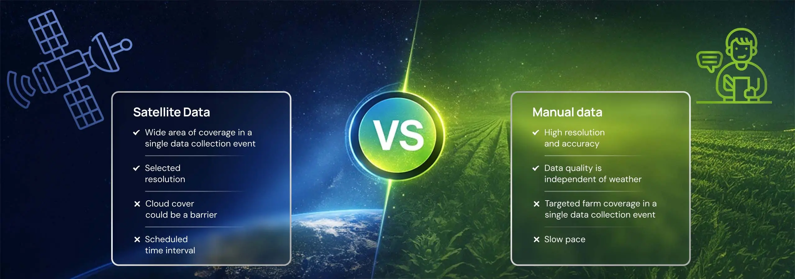
Satellite imagery captures farm-level data from the sky. It is the only way to maintain a “constant monitoring” on vast, fragmented territories. Satellite technology has matured into a reliable engine for macro-level visibility. It has become more affordable and offers huge benefits for farm management, enhancing field productivity. Here are some use cases
Wide-Area Crop Health Monitoring
Satellites allow you to monitor thousands of acres simultaneously. By using vegetation indices like NDVI or NDRE, enterprises can visualize which regions are thriving and which are lagging. This knowledge can be further augmented by sending field scouts to assess and work on corrective measures. Farmers can determine the need and quantity of fertilization.
Yield Prediction and Trend Tracking
Satellites excel at historical analysis. By analyzing historical vegetation growth patterns, AI models can predict harvest potential with high accuracy months in advance. From satellite images, AI models can also determine the optimal times to sow, fertigate, and harvest. With this knowledge, the procurement teams can stabilize their supply chains.
Water and Stress Monitoring at Scale
Precipitation and water indices, such as LSWI, captured by satellites, can flag irrigation failures (as a simple pipeline issue) or drought stress across entire districts. This is critical for high-value crops where a few days of water stress can permanently stunt growth.
Pest, Disease & Risk Pattern Detection
While satellites cannot capture a single insect or a diseased plant, they detect the “spectral signature” of a forest or field under attack. By identifying these patterns early, enterprises can deploy localized interventions before a localized issue becomes a regional epidemic. AI models can also alert about disease probability weeks in advance by considering historical patterns and weather forecasts
What Ground Intelligence Does Well
Now that we have seen where satellite monitoring thrives, let us also quickly list what ground intelligence does well. In many ways, ground data provides the “truth” that remote sensing can only estimate
Hyper-Local Soil and Sub-Surface Insight
While satellites look at the canopy, ground intelligence thrives in the soil. Soil sensors provide real-time data on moisture at specific root depths, salinity levels, and nutrient availability. Satellites cannot even see such a “below-the-surface” view. Similarly, when one needs data to predict yield for trees, where the produce, say a mango fruit, is covered by the canopy, ground intelligence prevails.
Real-Time Micro-Climate Accuracy
Satellites often rely on regional weather models. Ground-based weather stations provide the actual temperature, humidity, and wind speed of a specific field. For sensitive operations like spraying or frost protection, this precision is non-negotiable.
Physical Validation and Diagnostic Detail
A field scout or a high-resolution sensor can identify the exact species of a pest or the specific strain of a fungus. Ground intelligence provides high-definition clarity that allows precise, targeted chemical applications. This prevents wasteful broad-spectrum treatments.
Zero Latency and All-Weather Reliability
Ground sensors are unaffected by cloud cover. They provide continuous data 24/7, regardless of atmospheric conditions. This makes them the primary source of truth during heavy rainy seasons when satellites are often “blind.”
Limitations: Where Ground Intelligence Falls Short
Ground intelligence, consisting of IoT sensors, weather stations, and manual scouting, provides high-fidelity data. Despite this, it is fundamentally ill-equipped for the “Enterprise Scale.
Sparse Sensor Coverage Across Vast Acreage
For sensors to provide accurate data across a region, you would need one hardware every few meters. Now consider 10,000 hectares of farmland. The number of sensors required becomes both a logistical and an investment nightmare. If not enough sensors are used, you pave the way for “data holes” where the sensor reports one thing, but the reality 50 meters away is entirely different.
Maintenance, Deployment, and Cost Burden
Hardware breaks! Sensors need batteries, connectivity, and cleaning. The cost of maintaining a massive sensor network often outweighs the value of the data it collects. For many enterprises, the “Total Cost of Ownership” for ground hardware is a major ROI killer.
Human Scouting Doesn’t Scale
Relying on agronomists to manually scout every field is the most expensive way to collect data. Humans are subjective, they get tired, and they cannot be in ten places at once. At scale, manual scouting becomes a “check-the-box” exercise rather than a true data collection mission.
Fragmented, Isolated Ground Data
Ground data often lives in silos. The weather station data is in one app, soil moisture in another, IoT and drones in yet another and scouting reports are on a clipboard. Without a unified layer, this data is just noise.
Point Data Without Spatial Continuity
A sensor provides point data. It tells you exactly what is happening at its specific coordinates. However, it cannot tell you how that condition is spreading across the field. It lacks the spatial context that a map provides.
Limitations: Where Satellite Intelligence Reaches Its Limits
Despite its strengths, satellite monitoring comes with its own set of limitations. Cloud cover can blind optical satellites for weeks, especially during the critical monsoon or rainy seasons. Furthermore, a satellite can tell you that a crop is “stressed,” but it cannot tell you if that stress is caused by a specific nutrient deficiency, a soil-borne pathogen, insect or even virus. This is the “Diagnostic Gap.”
A Case Point: "Zone Sampling" – Where Scale Meets Science
The most compelling example of integrating these two worlds is the shift from random sampling to Smart Sampling or Zone Sampling. Traditionally, yield estimation relies on agronomists walking “randomly” through a field or visiting fixed points to take samples. The problem? Fields are heterogeneous; a random sample might hit a “golden patch” or a “dead zone,” leading to skewed data that misrepresents thousands of acres.
By integrating satellite and ground data, this process is transformed:
- Satellite Intelligence first maps the field’s heterogeneity, identifying distinct zones of high, medium, and low performance.
- Smart Sampling algorithms then calculate exactly where scouts should go to get a statistically representative sample of the entire field.
- Ground Intelligence (the physical sample) is then collected at these high-priority coordinates.
This synergy removes human bias and “randomness.” It uses the satellite’s “eyes” to tell the ground team exactly where their expertise is needed most, ensuring that the final yield prediction is rooted in both global visibility and local truth.
The Shift Towards an Integrated Approach in Agriculture
True data integration means satellite and ground intelligence are not just co-existing but actively merged into one normalized dataset, eliminating the gap between “what is seen” and “what is known.”
The most successful agri-enterprises are moving away from “Satellite vs. Ground” and toward an Integrated approach.
Satellite Intelligence for Surveillance and Early Signals
In this model, the satellite acts as the “early warning system.” From the satellite imagery of the entire portfolio, AI models flag “anomalies.” Instead of scouting everything, agronomists only scout the areas flagged.
Ground Insights for Validation and Root-Cause Analysis
Once the satellite flags an issue, ground intelligence (sensors or a targeted scout) is used to diagnose the root cause. The ground data validates the satellite signal, providing the “ground truth” needed for a high-stakes decision
AI as the Orchestrator of Multi-Source Farm Intelligence
Modern farming taps AI. Machine learning models ingest the satellite imagery, the ground sensor data, and multiple other datasets, including historical trends, to derive Decision-Ready Insight. It replaces the guesswork with science to tell enterprises exactly what to do, where, and when.API integration is the technical bridge that connects satellite feeds, ground sensors, and enterprise systems, ensuring data flows in real time without manual extraction or reformatting.
Conclusion
At enterprise scale, relying on a single source of intelligence is a risky strategy. Satellites give you the scale, and ground data helps you deep dive. By integrating both through a sophisticated AI platform like Cropin Cloud, enterprises can eliminate blind spots, protect their margins, and build a truly resilient supply chain. In the race to 2030, the winners won’t be those with the most data, but rather those with the best-integrated intelligence.For agri-businesses like commodity traders, food processors, seed producers, and food retailers, managing sourcing across multiple geographies, this integrated intelligence model provides the regional crop-health visibility needed to confidently validate supply commitments.
Frequently asked questions (FAQs)
Why do intelligence failures increase as farm operations scale?
Complexity grows exponentially with acreage. Communication gaps, data silos, and the physical inability to monitor every hectare lead to “blind spots” where risks go undetected until they impact the bottom line.
What types of agronomic decisions are most impacted by intelligence gaps?
Re-sowing decisions, irrigation intelligence, and pest intervention. Missing the window for any of these by even 48 hours can lead to significant yield penalties.
Why does satellite intelligence perform better at regional monitoring than field-level execution?
Satellites provide a bird’s-eye view that is perfect for spotting trends. However, field-level execution often requires a “hands-on” diagnosis that satellites alone cannot provide without ground validation.
What are the hidden costs of relying heavily on ground-level intelligence?
Beyond the initial purchase of the hardware, costs include battery replacement, data transmission fees, hardware theft/damage, and the substantial labor costs of manual data collection and maintenance.
How do intelligence blind spots affect multi-region or multi-crop enterprises?
They lead to inconsistent quality and unpredictable supply. One region might over-perform while another fails silently, making it impossible to meet global procurement contracts reliably
What does “decision-ready intelligence” mean in enterprise agriculture?
It means data that has already been analyzed and contextualized. Instead of a map showing “low NDVI,” decision-ready intelligence tells the manager: “Plot 42 has a 15% yield risk due to moisture stress; increase irrigation by 20% today.”
How does integrating satellite and ground intelligence reduce enterprise risk?
Integration provides a “fail-safe.” If clouds block the satellite, sensors provide data. If a sensor fails, the satellite provides broad context. Together, they ensure continuity of monitoring.
What role does AI play beyond prediction in agricultural intelligence systems?
AI acts as the “translator” between different data types. It cleans “noisy” sensor data, fills in gaps during cloud cover, and correlates disparate signals to find the hidden “why” behind crop performance
How does Cropin support intelligence consistency across regions and seasons?
Cropin’s platform acts as the unified intelligence layer. It standardizes data from any source (satellite, IoT, or manual) into a single dashboard, ensuring that a manager in headquarters sees the same high-fidelity truth as a field officer in Brazil.
Author Bio

Haripriya Muralidharan
Haripriya Muralidharan leads content marketing at Cropin Technology Solutions, bringing a unique scientific rigor to brand storytelling. With a Master's in Chemistry from Pune University and research experience in cancer immunology, she discovered her passion in storytelling. For two decades, she has operated at the intersection of content, communication, and brand strategy, specializing in turning complex ideas into impactful narratives. Prior to Cropin, Haripriya leveraged her creative skills at Elsevier’s Chemical Business News Base and shaped multi-format content strategies for B2B marketing at Scatter.